-
Picking Back Up
I guess we’ll try to pick back up approximately where we left off.
-
A student submitted a homework bug report asserting that the answer to the problem should be some other number, and the student justified this value with some remarkably specious reasoning that the student attributed to his father. Due to various student privacy policies, I don’t have the ability to reply to this student, but if I did, I would be tempted to say, “Please don’t let your father ‘help’ you with math homework ever again.” The only bright spot is that in the initial report the student did not inform us that the father works in a STEM profession. It’s always the worst when you get a student adding fractions by adding the numerators and then adding the denominators and then claiming that this method was recommended by a parent with a PhD in math.
-
I keep buying the cookies in the cute tins where the lids don’t fit quite right and eating all the cookies and ending up disappointed by the tins. But the cookies are so yummy, and the tins are so close to being very nice tins.
-
The universe is telling me that I should just pick a health insurance plan at random. Well, that is not true. Half the plans would let me see the doctors that I already see (PPO), and half the plans would make me pick all new doctors for everything (HMO). But of the plans that would let me see the same doctors that I’ve been seeing, there are inconsistencies between the various documents describing what is covered, and there are inconsistencies in the pricing. Also, our “open enrollment” only lasts three business days. Since two of my doctors have been throwing around the initialism “MRI”, I’m thinking that I’m just going to pick the “gold” plan and be done with it.
-
We did a brand refresh at work, which means that all the fonts and colors changed. This also means that we need to recompile all the TeX documents. Wish us luck.
-
-
Even Briefer Update
Still not much to say.
I’ve been spending my time binge-watching various TV shows that I can watch for free via Amazon. I watch The Romanoffs so that you don’t have to.
Also I’ve started working on Kon-Mari again. I’ve bought a bunch of stuff since I started throwing everything away, so I need to get rid of a lot of things just to get to where I was when I gave up. This weekend’s almost-triumph is that I’m within striking distance of no longer using the second bathtub as an improvised closet. If I can find a space for the very large suitcase that still remains in the bathtub, then I will throw away the two boxes that are keeping it company.
Such is the glamor of living in an 840 square foot apartment after having spent a decade living in a 1420 square foot house with remarkably high ceilings (suitcases could be stored on high shelves in closets) and a basement and a garage.
I just opened up a private window in the browser where I’m not signed in to anything and have verified that if I want to buy a house-house with more square feet than this apartment, I’m going to need three quarters of a million dollars.
-
Brief Update With Airplanes
Still been working on the airplanes. Haven’t been in the mood to write anything here because my allergies have been bugging the heck out of me for the past many days, and that has made me somewhat uninspired about writing about stuff.
At least temporarily I have the airplanes in the cloud for you to see. Still a lot of work to be done; I want to get the daily file of plane data to move from the Raspberry Pi into The Cloud without my interfering with it. My hunch is that the best way to do that is to install the AWS command-line tools on the Pi and then set a cron to move the daily file into this bucket.
At least until I take them down, you can take a look at the first decent draft.
-
Nerd Hobbies
I haven’t had much to write about because I have been spending most of my free time working on stuff relating to my nerd hobbies. By which I mean computers and airplanes.
I took a screen recording and turned it into an animated GIF, but the real version of this is in JavaScript. This is the path that Qantas 7 took yesterday when it was flying over San Diego County on its way from Australia to Dallas. Yes, I did not get all of the positions from out over the ocean; I had set my filter too conservatively.
Remaining issues to be dealt with:
- How to visualize an undetermined number of planes?
- Having the visualization develop over time in a pleasing way.
- Getting the data into The Cloud.
- Better colors.
-
Tuesday Omens
-
A debt collector called at quarter after six this morning trying to get in touch with someone else with my name. The representative on the phone probably doesn’t realize how very common my name is.
-
My car complained: TIRE PRESSURE LOW. I drove to work as normal. I figured that with the cooler weather we’ve been having as fall has settled in, this is some sort of \(PV = nRT\) thing and that the pressure has fallen just barely below some programatic threshold. Would sure be nice if the car told me which tire(s).
-
Even though I ordered a hot drink, Starbucks made my drink iced. Yes, I did ask the barrista to re-make it.
-
-
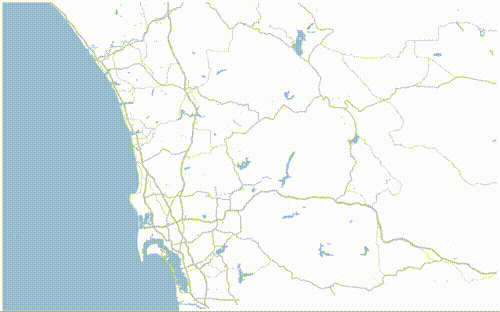
Teetering on the Edge of the Rabbit Hole of Map Projections
For one of my side projects, I’m making a map of San Diego County and adorning it with various features. I’m using d3 (because I’m obsessed with d3 this month), so my map needs to be represented with GeoJSON. If you don’t know about GeoJSON, it is basically a list of vertices of your region as (longitude, latitude) pairs.
One of the important features of San Diego County is that it shares a border with Mexico. The border with Mexico is linear (at least in some map projections), but it does not fall exactly on a latitude line.
One of the other important features of San Diego County is that it shares a border with the Pacific Ocean. The ocean is very large and mostly non-linear, and the public domain shapefiles from the US Census only show the ocean for some fixed distance away from the coast. The polygon is also clipped at the Mexican border.
(Gee it would be nice if I included an image to show what I’m talking about, but right now all of my map files are kind of broken.)
My goal here is to edit the GeoJSON (list of vertices) so that the ocean polygon extends linearly along the Mexican border, has a vast blue region representing So Much Ocean, and then comes back, linearly, along the Orange County border.
So the problem is: If a set of (longitude, latitude) points that are already in the GeoJSON file (i.e. the Mexican border) lie along the same line in (x, y) space when transformed to the Mercator projection, how can I extrapolate that line out into the ocean? Where can I find some sort of inverse-Mercator function to take the desired points in my image and map them back to (longitude, latitude) pairs?
-
The Weekend In Review
Subtitle: Briefly.
-
Panera, Liberty Station: As always, the staff is over-worked and under-prepared. People are going to go to Panera on a weekned morning and order coffee and bagels? Color them shocked. Eternal pro: There is that really big table, and they never make the knitting group feel unwelcome.
-
The Man in the High Castle: Finished watching it today. This season seemed to make a lot more sense than last season. That isn’t necessarily a good thing. I think that my favorite part of the show is the Nazis’ costumes.
-
The Romanoffs: Are they episodes of a television series or are they short films? So far they are kind of boring. If you want to watch an anthology-style television series, you should watch Dekalog. If you can’t find it on your favorite streaming service, come over here, and we can watch it on DVD.
-
PartyCity: Excellent selection of plastic spiders. Last year I was unable to replenish my plastic spider supply because I wasn’t driving because of all of that neurology stuff.
-
subscribe via RSS